Kansas City is a sprawling, bi-state metropolitan area where transportation options have evolved significantly over the past few years. Whether you are moving to the area or just visiting Kansas City, understanding the local transit network makes navigating the urban core and surrounding suburbs much easier.
The region has traditionally been heavily car-dependent, but recent infrastructure investments are shifting that dynamic. From the newly expanded streetcar lines to the modernized airport, getting around Kansas City MO requires knowing which routes and transit systems best serve your daily routine.
Buyers exploring homes for sale in Kansas City often factor commute times and public transit access into their neighborhood choices. Reviewing a local transit map and bus schedule helps narrow down the search for the right property.
Arriving in KC: Navigating from Kansas City International Airport (MCI)
The first transportation experience for many new arrivals happens at Kansas City International Airport. The modernized, $1.5 billion single terminal opened in early 2023, completely overhauling how travelers enter the region.
This consolidated layout replaced the old horseshoe design, making baggage claim and ground transportation much more intuitive. Renting a car is straightforward, with facilities accessible directly via a dedicated shuttle from the terminal.
For those heading straight to downtown Kansas City, the airport sits about 20 miles northwest of the city center. A typical drive from MCI down I-29 takes around 25 to 30 minutes, depending on the time of day.
If you prefer not to drive, taxis and rideshare services operate from designated pickup zones just outside arrivals. The regional transit authority also provides bus service through specific RideKC routes that connect the airport directly to central transit hubs.
Driving in Kansas City: Major Highways and Traffic Patterns
Despite ongoing public transit expansions, the Kansas City metropolitan area remains primarily a car-centric region. Navigating the city effectively requires familiarizing yourself with the major highway loops that connect the Missouri and Kansas sides.
The downtown loop is formed by the convergence of I-35, I-70, and I-670, acting as the central hub for regional traffic. I-435 serves as the massive outer beltway, allowing drivers to bypass the city center when traveling between northern and southern suburbs.
Rush hour congestion is a reality, but it is generally less severe than in similarly sized coastal cities. Peak traffic typically builds between 7:30 AM and 8:30 AM, and again from 4:30 PM to 5:30 PM along the I-35 corridor.
The average commute time for a resident in Kansas City, Missouri, hovers around 22 to 24 minutes. Buyers evaluating living in Kansas City often find that easy access to these major interstates keeps travel times highly predictable.
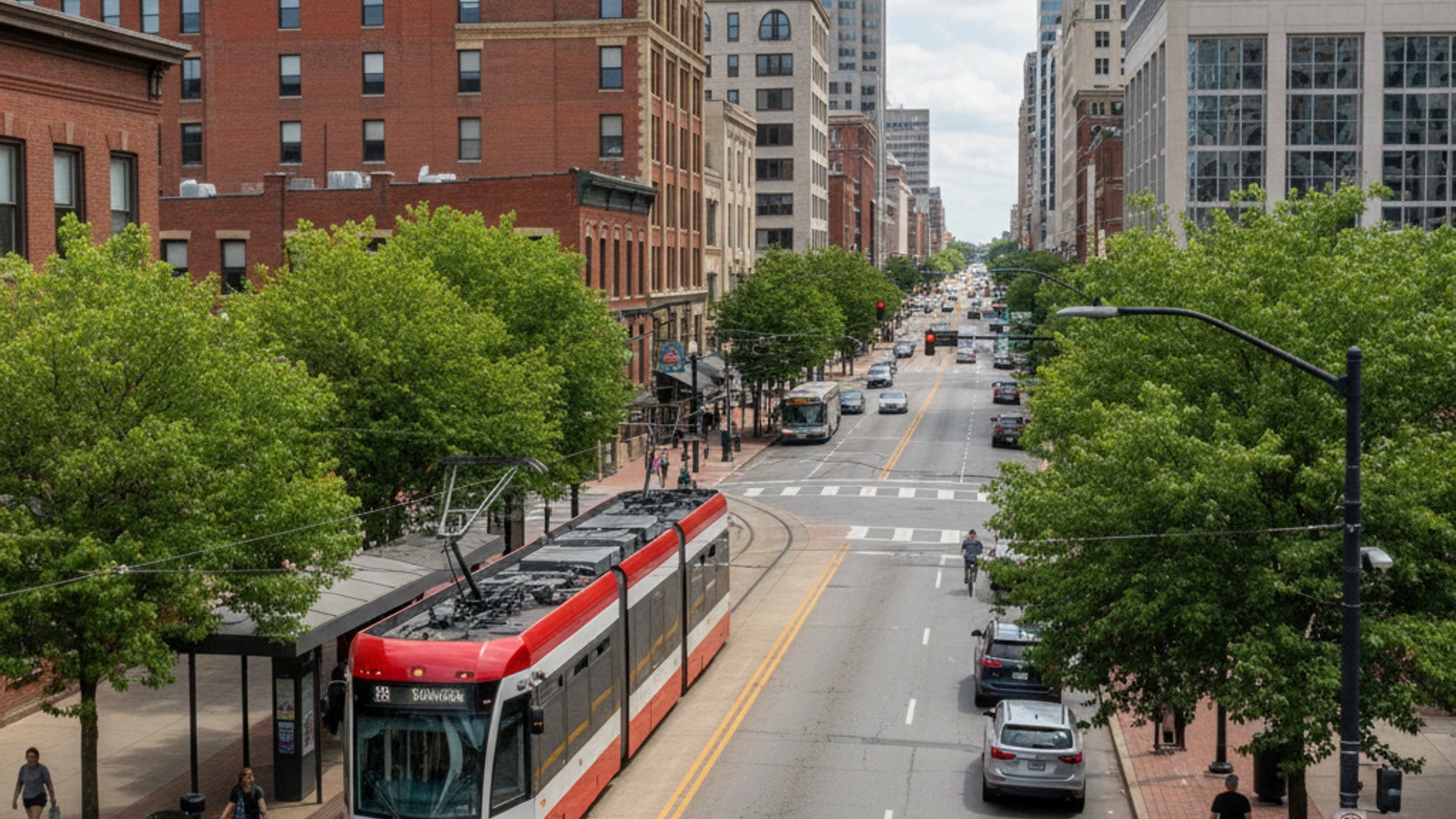
Public Transit: Riding the KC Streetcar and RideKC Bus
Public transit in the urban core has transformed dramatically over the last decade. The Kansas City Area Transportation Authority manages a comprehensive network that serves daily commuters and tourists alike.
The KC Streetcar is the premier transit option connecting the River Market, Downtown, the Crossroads Arts District, and Union Station. This tram system saw a major milestone in October 2025 when the Main Street extension south to the University of Missouri–Kansas City officially opened.
Further expansion is underway, with a northern riverfront extension expected to begin service later in 2026. This rail network integrates seamlessly with the RideKC regional bus network, which provides extensive coverage across the entire metro area.
A crucial update for riders involves the cost of the RideKC bus system. After operating under a zero-fare policy for several years, standard bus fares are returning on June 1, 2026, with a proposed $2.00 base fare for most local routes.
Walkability and Bike Infrastructure in KC Neighborhoods
Finding walkable neighborhoods is a top priority for many buyers moving to the city center. Several distinct districts offer excellent pedestrian infrastructure and easy access to daily amenities without needing a car.
The urban core is highly interconnected, with dedicated bike lanes and wide sidewalks supporting non-motorized transit. Electric scooters and local bicycle-sharing systems are stationed throughout these areas, serving as a practical last-mile solution for commuters.
The Trolley Track Trail provides a dedicated, paved path for cyclists and runners stretching from the university area down through the southern neighborhoods. This infrastructure makes navigating the city without a vehicle increasingly viable for residents in central districts.
Several key neighborhoods stand out for their exceptional pedestrian access and minimal car dependency:
- Downtown and River Market: These adjacent neighborhoods feature dense housing, grocery access, and immediate streetcar connections.
- Crossroads Arts District: Known for its grid layout, this area offers easily walkable blocks filled with galleries, offices, and dining.
- Country Club Plaza: This historic district features wide pedestrian pathways, integrated retail, and dense residential blocks.
Ridesharing, Taxis, and Other Transportation Options
When public transit routes do not align with your schedule, on-demand transportation fills the gaps across the metropolitan area. App-based services ensure you can always secure a ride, regardless of which neighborhood you are in.
Uber and Lyft are heavily utilized throughout the region, offering quick pickups from the airport to the deep suburbs. Traditional taxi services also maintain a strong presence, particularly around major hotels, Union Station, and entertainment districts.
Micro-transit options have become increasingly popular for residents needing flexible, localized rides within specific zones. These app-based regional mobility services operate similarly to rideshares but are integrated with the local transit authority to keep costs predictable.
For those commuting from the outer suburbs into the city, park-and-ride facilities offer a highly convenient hybrid approach. Drivers can leave their cars at designated lots near major highway interchanges and catch an express bus into the downtown core.
Kansas City Transportation FAQs
Is the metro still free in Kansas City, Missouri?
The KC Streetcar remains entirely free to ride for all passengers. However, the RideKC bus network is ending its zero-fare program, with a standard $2.00 base fare returning on June 1, 2026.
How to get around Kansas City without a car?
Navigating the city car-free is easiest when living near the urban core or along the Main Street corridor. Residents combine the free KC Streetcar, the RideKC bus network, and local bicycle-sharing systems to reach their daily destinations.
Is KC Streetcar free to ride?
Yes, the streetcar is completely free to ride and does not require a ticket or pass. It operates daily, connecting major hubs from the River Market down to the University of Missouri–Kansas City extension that opened in 2025.
Is there a free shuttle from Kansas City Airport to downtown?
There is no dedicated free shuttle connecting the airport directly to downtown Kansas City. Travelers must use a paid taxi, a rideshare service, or the RideKC bus routes that serve the MCI terminal.

Dani Beyer, a Kansas City native, began her career in real estate in 2004 after working in the tech industry. Since then, she's helped thousands of families turn their dreams into keys! Dani is now the CEO and Lead Listing Specialist of 'Dani Beyer Real Estate' brokered with Keller Williams KC North. With 820+ Five Star reviews, she specializes in helping buyer and sellers in the Kansas City Northland.